Mapping in citizen engagement isn’t a new thing. People have been consulting about – for example – planning and road network changes since long before the internet rose to prominence.
Now, however, the technology has caught up.
This is down to progress in two areas: firstly, how maps have developed in the consumer tech space, particularly on smartphones. Think of products like Uber and Google Maps. These have not only massively increased people’s understanding of GIS (Geographic information system) technology and maps, but also given citizens an increased spatial awareness of their neighbourhood.
And secondly, there’s been a lot of public sector investment in GIS technology, with initiatives like the Public Sector Geospatial Agreement from Ordnance Survey and the UK Government’s Geospatial Commission. Initiatives like these have made it easier and more cost effective to access high quality open GIS mapping data. This really opens up a whole new world of possibilities when it comes to engagement.
Maps now have the potential to be an extremely useful tool for any engagement activity that is linked to a specific place. They can be used for sharing information, helping users find the parts of a survey that they care about or as a tool to receive feedback and ideas.
Read on for some ways maps and geospatial can transform digital engagement. You can also watch Delib’s product manager, Ally, explaining how to use Citizen Space Geospatial to improve your citizen engagement in the video below.
Using Digital Maps To Learn More

Digital maps are an incredible tool for informing people. In their simplest form, maps are an effective way to anchor your activity to a place. By highlighting the location an organisation is referring to on a map, citizens can see how it relates to other places that are important to them – for example, their home or their work.
From this starting point, additional information and data layers can be added. This extra information can show patterns across a neighbourhood, help tell the story of a decision an organisation needs to make, or demonstrate exactly how a plan or decision will impact a place. This can be done on a large scale, for example showing the spread of facilities across a city; or a small scale such as converting a detailed local highways plan so people can see what changes are proposed.
Often, place-based information is displayed using CAD drawings, which are usually difficult to read and understand, as well as being found in a file the user has to download to access. Digital maps provide another way to tell a story and provide information in a way that enables respondents to feel more connected to what you’re telling them than if you were to describe a location in text or use visually confusing documents.
Using Maps for Citizen Engagement Projects

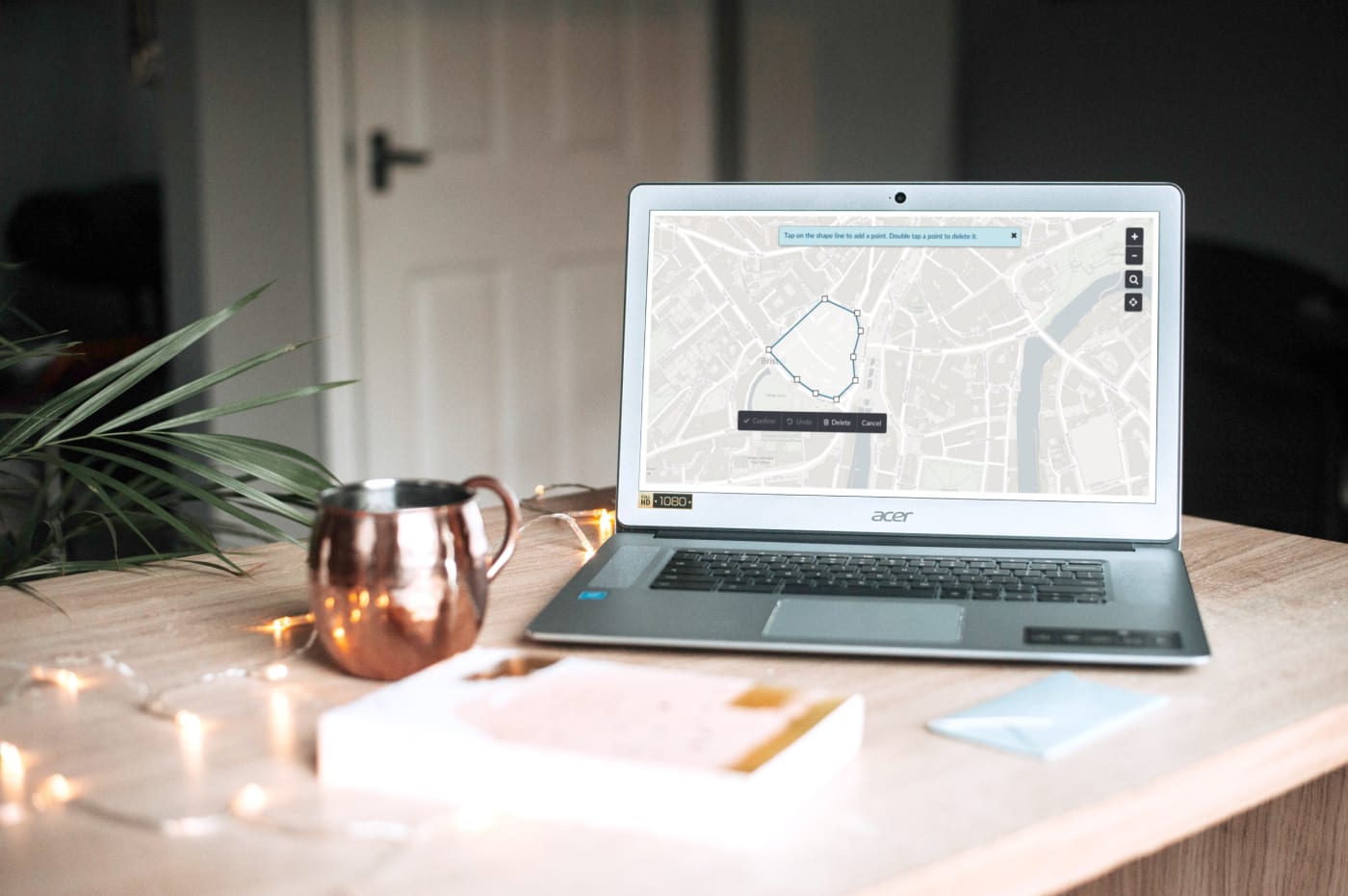
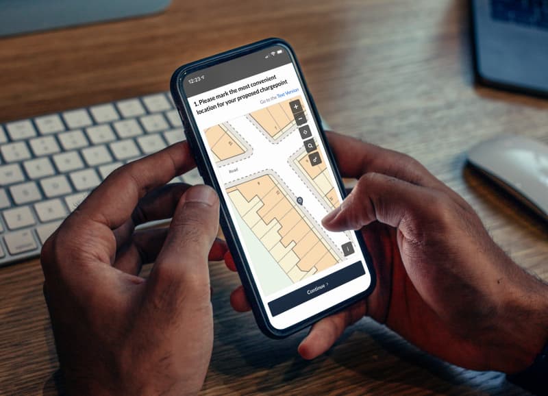
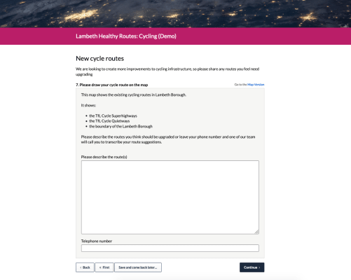
Maps can also be used as a tool getting feedback and ideas from citizens. Interactive maps are an extremely powerful way to get rich data that leads to informed decisions. Geospatial response data paints a deeper picture and enables organisations to more deeply understand what’s going on in their constituency, particularly when geospatial data can be cross-referenced against other response data for better spatial analysis. Citizen Space Geospatial allows users to drop a pin, draw a route or draw a shape as their response.
Getting users to draw on the map gives a rich new mechanism for understanding their views in a geographic context. This might be simply getting them to drop a pin to give a precise location, through to drawing a line to show something like a route they might take through geographical areas, or getting them to draw a polygon to mark out an area or site.
Using interactive GIS mapping software over paper processes is a huge time-saver for people running statutory exercises such as Calls for Sites or Local Plans, as well as transport planning exercises like TROs. Often respondents are asked to draw on a paper map and scan/upload it to their submission, which ultimately increases the burden on the consulting organisation as well. Interactive mapping eliminates manual processes and generates GIS data rather than documents, saving everyone time and effort.
Maps throughout the decision-making process

These different uses for maps can be used at different points throughout a decision making process. They can be used early on when an organisation is trying to gather ideas and options for a proposal.
For example, asking respondents to draw on a map to illustrate where they might want something, or showing a simple map to anchor people on the neighbourhood the proposals are focusing on.
Maps can be used to show different options, or to ask people to pick their preferred option – for example which proposed route they think a new cycle path should take. When the proposals have then been narrowed down to a single idea, maps can be used to understand specific feedback for a particular purpose. People can easily visualise your idea, select an element of the map to comment on or mark a location on the map where they have an issue.
Lastly, when a decision has been made and you need to notify the public, including a map is critical information and context. With Citizen Space Geospatial, you can publish spatial data where consent has been given to do so on a digital map.
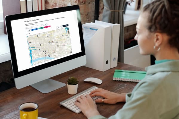
Example of a Published Response to a ‘Call for Sites’ in Citizen Space Geospatial

This isn’t an exhaustive list and there are plenty of other opportunities for mapping and geospatial data to shake up digital engagement even further. If you’re interested in adding geospatial capability to your Citizen Space subscription do get in touch.
Introducing place-based engagement with Citizen Space Geospatial
Include maps and geospatial data throughout your consultation and engagement activities.
We’re confident that Citizen Space Geospatial solves a lot of problems for a lot of people. But who defines those problems and how specifically do you solve them?
Citizen Space Geospatial was designed based on user research involving over 20 government organisations. You can read about the user research journey here.
How did we go about building Citizen Space Geospatial? What were the challenges? You can read about the engineering journey here.
How can geospatial tools include people who, for whichever reason, can’t use a map? Read about how we designed for accessibility and inclusion.
What is geospatial data? Why is it important for democracy, consultation and engagement activities? Read a detailed overview.
To find out more about Citizen Space Geospatial book a demo and we’ll walk you through it.