
Many UK local councils use Citizen Space to publish notices of their Digital Traffic Regulation Orders, as well as gather geospatial responses from citizens during public consultation. It’s a big topic of conversation at the moment, as planning authorities are being asked to revisit their transport plans under Labour’s NPPF update.
On this page, we’ll walk you through the legal backdrop to D-TROs, and how our platform stays compliant with the UK Department for Transport’s new rules in 2024.
What is a TRO?

Traffic Regulation Orders, or TROs for short, are rules that manage how vehicles use public roads. They were created under the authority of the Road Traffic Regulation Act of 1984, but it’s the local councils and transport managers who actually use this Act to create specific TROs for their areas.
TROs are legally-binding instruments that are enforced by the police, parking wardens, or local highway authorities. You don’t want to be caught out, either, because doing so carries a criminal penalty and a fine of up to £1,000.
What are TROs Used For?

Okay, that’s the legal TRO meaning, but you’ll understand them better with a few real-life examples:
- Speed Limits: The most common and recognisable type of TRO is a vehicle speed limit. In fact, the recently scrapped Welsh Government’s blanket 20mph law is a great example of a large-scale Traffic Regulation Order.
- Changes to a Road Network: Features like one-way streets, low-traffic neighbourhoods, and new cycle or bus lanes all require a TRO before street signs go up and road markings are painted.
- Vehicle Restrictions: TROs are often used to prevent ‘rat-running’ on quiet residential streets. They’re sometimes used in historic town centres to divert heavy-goods vehicles that would otherwise cause noise, vibration, and road surface damage.
- Parking Restrictions: TROs can determine where, when, and how long vehicles are allowed to park. Common examples include “permit holders only” areas, loading bays, or Blue Badge zones. In especially narrow streets, you may even notice signs that permit cars to park on the pavement.
- Idling Restrictions: TROs can also prevent cars from engine idling outside places like schools or hospitals, reducing public exposure to smelly and harmful exhaust fumes.
Different Types of TRO

There are three main types of TRO that a local council can introduce; permanent, temporary, and experimental (E-TRO) schemes.
Permanent TRO schemes essentially do what they say on the tin and require extensive public consultation before they can take effect. In some cases, this process can take up to 18 months!
Temporary Traffic Order Regulations (TTROs) only require a 3-week announcement window, making them perfect for closing roads for maintenance or street parades.
E-TROs are a bit more flexible. They might be used for something like an e-scooter trial, which is temporary at first but may be made permanent at a later date. It’s useful for local councils because the consultation process isn’t so costly or time-consuming, although they’re still required to gather and listen to public feedback.
Digitising TROs

Nowadays, people spend so much time looking at their phone screens that they might not spot a TRO notice popping up on their street… And we’re only half-joking, because there’s now a serious need to digitise the paper trail of road regulations.
These digitised versions are aptly named Digital Traffic Regulation Orders, or D-TROs. Essentially, they take all those existing rules about parking, speed limits, one-way systems, and more, and translate them into a language that computers can understand.
During the pandemic, most local councils moved their public engagement methods online. This extended to publishing traffic regulation orders on the council website, alongside the usual street notices and newspaper announcements.
They also started running more online transport consultations, because it’s much easier for everyone — citizens and planners alike — to see what proposed changes will look like on an interactive digital map.
It’s expected that D-TRO’s will soon become a legal requirement as a way of standardising and modernising the entire Traffic Regulation Order process. Local authorities will be expected to share digital info on all traffic orders with the Department of Transport, and the easiest way to do that is to look toward digitisation now.
In 2024, the government created new powers for the Department for Transport under the Automated Vehicles Act. A new D-TRO service was launched in September where local authorities can share digital info on all of their traffic orders to a central repository — as a way of standardising and modernising the entire Traffic Regulation Order process. Once the trial period concludes and the public has been consulted, it’s widely expected that D-TROs will become a legal requirement for councils in England and Wales.
The Role of Geospatial Data In Digital TROs

Digital TROs are a great example of spatial planning in action. You need to know exactly where a parking restriction applies or what the speed limit is on a specific stretch of road. This is where geospatial data comes in — because it provides the geographical context for those digital rules.
The DfT uses a specific digital format called JSON to handle this data. However, many local authorities already manage their traffic orders using specialised mapping software known as Geographical Information Systems (GIS). The Google Maps API is a popular example you see on many council websites.
This is where Citizen Space Geospatial steps in to simplify the process. Our platform acts as a bridge between your existing GIS data and the DfT’s requirements. Using Citizen Space Geospatial, you can import and export those complex maps and location-based rules into a GeoJSON format, perfect for creating D-TROs without the need for manual data re-entry.
Using Citizen Space for D-TRO Consultations
Citizen Space is useful for more than just publishing notices — you can also use it to collect enriched geospatial responses during your TRO consultations. Just imagine, local residents could see exactly where changes will take place and pinpoint their comments by drawing directly on the map. Perhaps they have a better idea for where a pedestrian crossing could be built, or maybe they’re concerned about how a bus stop location could impact traffic flow…
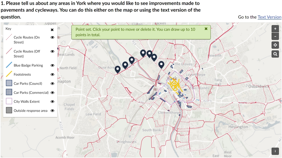
When the City of York Council set about creating a new Local Transport Plan back in 2023, they used Citizen Space Geospatial for this exact purpose. Looking at the map below, you can see just how easy it was for respondents to leave precise, visual feedback for planners to make full use of.
The popularity of digital public consultation is also why Birmingham City Council have used Citizen Space for every one of their E-TROs since 2011. City planners and citizens alike have found the system easy to use, with its intuitive survey format, clear explanations of the consultation process, and robust geospatial tools.
“Citizen Space meets perfectly the part of our Consultation and Engagement Strategy requiring digital formal consultation. Our staff have taken to it easily and we have had overwhelmingly positive feedback.”
Kaja Carson, Policy Manager, Birmingham City Council
Benefits of D-TROs

While we’re on the subject, we thought now would be a great time to tell you about all the useful things D-TROs are doing for local democracy and transport policy in the UK.
Here are some of the clear advantages of a digital system:
- Centralised Data Hub: The DfT is creating a single, comprehensive database for all D-TROs in England and Wales, simplifying management and access to this information.
- Self-Driving Compatibility: Automated vehicles will be able to access up-to-date traffic rules, ensuring they comply with speed limits, vehicle restrictions, and other regulations.
- Real-Time Traffic Management: GPS systems will be able to tap into D-TRO data to provide real-time information to drivers, diverting them from road closures, maintenance works, or public events.
- Empowered Citizens: Finding information about local traffic notices is easy when it’s just a few clicks away. As for public consultations that require back-and-forth between government and people, having the information readily available online lives up to the Gunning Principles on transparency and accountability.
Challenges of D-TROs

As you may have guessed, the most significant hurdle with transitioning to D-TROs is in the technical side of things. Most local authorities already manage traffic orders within their existing GIS systems, which aren’t always directly compatible with the Department for Transport’s JSON data requirements.
During the D-TRO FAQ, many councils expressed concern over the potential time and resource implications — especially at a time when public budgets are already stretched thin. Given that the government has not promised any new funding to overcome this challenge, we think it’s time local councils were equipped with the tools they need for a painless digital transition.
We built Citizen Space Geospatial for exactly this reason. Our platform empowers local government to take full control of their D-TROs and transport planning process:
- Full Data Integration: Your existing GIS data can be translated to and from other systems, including shapefiles and GeoJSON, without any loss of quality.
- New Ways to Respond: Citizens can drop a pin, draw a shape, or draw a route on an interactive map of local TROs. No more text-heavy documents or paper trails.
- Detailed Analysis: We’ve got you covered on every stage of the D-TRO process, from gathering public feedback to analysing results and publishing finalised orders. Filter and segment public feedback according to geographic rules for more insight.
If you’ve already digitised your traffic rules in the government’s preferred JSON format, there’s no real cause for concern. But if your data is still stuck in GIS systems, Citizen Space can help make the transition easier.
In any case, now is a great time to evaluate how you run online consultations — and you might just find our tools are perfect for turning local traffic discussions into a genuinely engaging experience.
———
Hundreds of government organisations use Citizen Space to start meaningful conversations with local residents about the future of their streets. If you’d like to learn more about how our software provides planners with enriched geospatial data, book a free demo and we’ll walk you through it.